Tropical depression, tropical storm, hurricane: what changes at each step
A tropical depression, a tropical storm and a hurricane are the same kind of storm at different strengths. The National Hurricane Center (NHC) sorts them by wind speed: up to 38 mph (62 km/h) is a tropical depression, 39 mph (63 km/h) makes it a named tropical storm, and 74 mph (119 km/h) makes it a hurricane.
How NHC measures a storm's strength
All three are tropical cyclones, the NHC glossary term for a storm that forms over warm tropical or subtropical water and spins around a defined centre. What separates them is the maximum sustained wind: the strongest one-minute average wind near the surface. A single gust does not count, which is why a storm can produce gusts well above the speed in its name.
Tropical depression: a number, not a name
A tropical depression has sustained winds of 38 mph (62 km/h) or less. It gets a number, given in order through the season, so the ninth one in the Atlantic in a year is Tropical Depression Nine.
Low winds do not make a depression harmless. A weak, slow system can still drop a lot of rain, and the rain is often what floods.
Tropical storm: when the name arrives
At 39 mph (63 km/h) the depression becomes a tropical storm, and that is the moment it takes a name. Tropical storms run up to 73 mph (118 km/h). The names come from six lists that rotate every six years, kept by the World Meteorological Organization, as NHC explains. A storm deadly or costly enough can have its name retired.
Hurricane: 74 mph and up
At 74 mph (119 km/h) the storm is a hurricane, and NHC rates it on the Saffir-Simpson Hurricane Wind Scale:
- Category 1: 74 to 95 mph (119 to 153 km/h)
- Category 2: 96 to 110 mph (154 to 177 km/h)
- Category 3: 111 to 129 mph (178 to 208 km/h)
- Category 4: 130 to 156 mph (209 to 251 km/h)
- Category 5: 157 mph (252 km/h) or higher
Category 3 and above are major hurricanes.
The category is about wind only
NHC is explicit that the scale does not account for storm surge, rain flooding or tornadoes, all of which can be deadly. So a lower category tells you about the wind and little else, and the rain can reach places well away from the centre. Our posts on reading the hurricane cone and flood watches and warnings cover that side of it. The watches and warnings for your area, explained in our piece on watches, warnings and advisories, say what to expect where you are.
Two more terms you may see
Before a storm forms, NHC can call it a potential tropical cyclone: a disturbance that is not a tropical cyclone yet, but could bring tropical storm or hurricane conditions to land within 72 hours. The label exists so advisories, watches and warnings can go out before the storm has formally formed.
At the other end, a storm that loses its tropical features becomes post-tropical. It can still bring heavy rain and strong wind.
An example: Isaias, October 2026
Isaias took the first of these steps in the Gulf. NHC began advisories on Tropical Depression Nine on 6 October 2026. Its advisory at 4 a.m. CDT on 7 October announced that the depression had become Tropical Storm Isaias, with sustained winds of 40 mph (65 km/h). NHC said it expected Isaias to become a hurricane by Thursday, and that hurricane watches would likely be needed for part of the US northern Gulf coast.
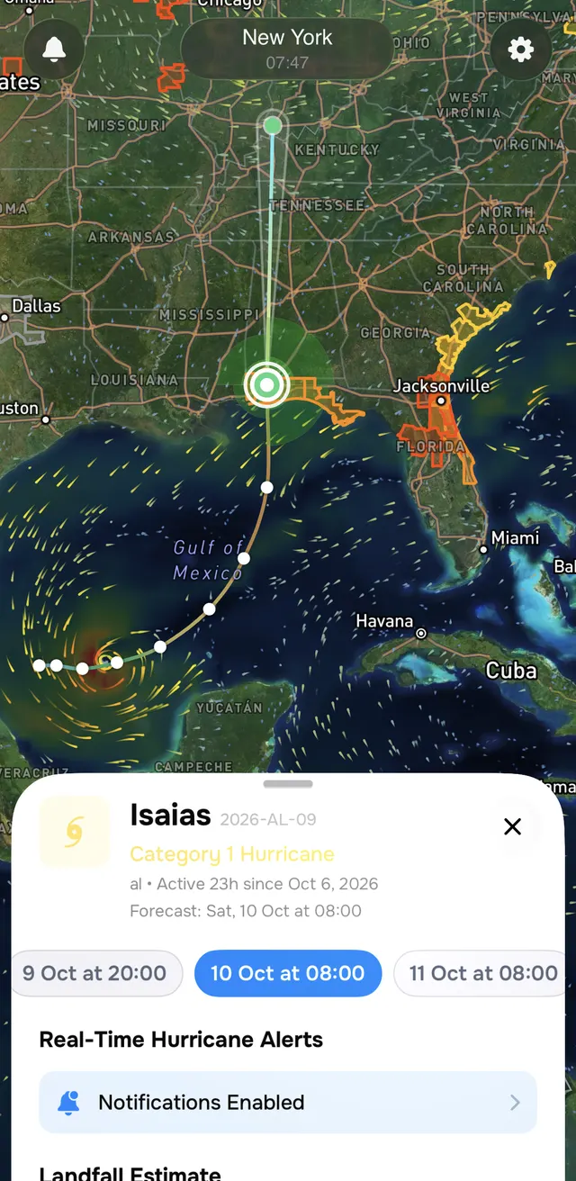
This is Isaias in the Ora Weather hurricane tracker on 7 October. The "Category 1 Hurricane" label is the forecast for Saturday 10 October, the point picked on the timeline, not the storm's strength when the screenshot was taken.
Where Ora Weather fits
On the free tier, the Ora Weather hurricane tracker shows a hurricane's current position and an estimate of when it could make landfall and how far that is from you. OraPlus adds the full forecast path and hurricane alerts, which is the view above. Severe weather alerts follow the official NWS classifications on both tiers, so a hurricane watch or warning appears under the name NWS gave it, with what is happening, what to do and when it ends. The official forecasts and warnings are issued by NHC and your local NWS office.
Common questions
- What is the difference between a tropical depression and a tropical storm?
- Wind speed. The National Hurricane Center calls a tropical cyclone a tropical depression when its maximum sustained winds are 38 mph (62 km/h) or less, and a tropical storm from 39 to 73 mph (63 to 118 km/h). The storm gets its name when it crosses into tropical storm strength.
- Why does a tropical depression have a number instead of a name?
- Names are given only once a system reaches tropical storm strength. Until then NHC numbers it in order through the season, so Tropical Depression Nine is the ninth depression in that basin that year.
- Can a tropical depression be dangerous?
- Yes. Wind speed decides the name, but a slow, weak system can still bring heavy rain and flooding. The watches and warnings for your area, not the storm's label, say what to expect where you are.
- What is a potential tropical cyclone?
- A term NHC uses for a disturbance that is not yet a tropical cyclone but could bring tropical storm or hurricane conditions to land within 72 hours. It lets forecasters issue advisories, watches and warnings before the storm has formed.
- What makes a hurricane a major hurricane?
- A major hurricane is Category 3 or higher on the Saffir-Simpson Hurricane Wind Scale, which means sustained winds of 111 mph (178 km/h) or more.